
The ICOW Territorial Claims Data Set
The territorial claims data set follows the general guidelines on the ICOW home page.
A territorial claim is defined as explicit contention between two or more nation-states claiming sovereignty over a specific piece of territory. Official government representatives (i.e., individuals who are authorized to make or state foreign policy positions for their governments) must make explicit statements claiming sovereignty over the same territory.
Please note that the ICOW Project and its directors do not take or endorse official positions on any territorial claims. Our goal is to identify cases where nation-states have disagreed over specific issues in the modern era, as well as measuring what made those issues valuable to them and studying how they chose to manage or settle those issues. Inclusion/exclusion of specific cases, and coding of details related to those cases, follows strict guidelines presented in the project's coding manuals (which are available below).
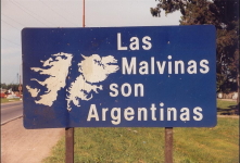

(1) an Argentine road sign claiming the Falkland/Malvinas islands;
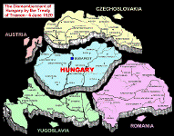
(2) a map of Hungary's territorial losses under the post-WWI Treaty of Trianon;
(3) an airstrip occupying almost an entire island in the Spratly chain.
Measuring Claim Salience
The salience of territorial claims is measured by a 0-12 index, which includes up to six points each for the claim's challenger and target states (one point each for six indicators of salience). For more details see the Hensel and Mitchell GeoJournal article listed below in the data set references section of this page. Three of these indicators cover tangible aspects of territorial claim salience:
- Resources: is the territory believed to contain potentially valuable resources?
- Strategic Location: is the territory considered to be a militarily or economically strategic location?
- Permanent Population: does the territory support a permanent population (either villages or at least one city of 100,000+)?
The remaining three indicators cover intangible aspects of claim salience, and are coded separately for each claimant:
- Homeland/Dependent Territory: is the territory claimed as homeland territory, rather than as a colonial or dependent possession?
- Identity Ties: does the state have an explicit ethnic, religious, or other identity connection with the residents of the territory?
- Historical Sovereignty: has the state exercised sovereignty over this territory within the past two centuries?
Project Participants
- Principal Investigator: Paul Hensel
- Research Assistants: Mike Allison, Cherie Bryant, Glynn Ellis, Taylor Fravel, Bryan Frederick, Kim Genger, Tim Haglund, Ed Hally, Danny Hill, Eric Keels, Chris Macaulay, Baris Ornarli, Shawn Rowan, Jackie Rubin, Bill Reed, Steve Shellman, Cliff Sherrill, Tom Sowers, Emily Stull, Ashly Townsen, John Tures
Current Status
Data on territorial claims, claim salience, and claim militarization for the whole world was released in 2013. Data on peaceful settlement attempts over territorial claims has been released for the Western Hemisphere and Northern/Western Europe for the years 1816-2001; a draft of peaceful settlements in the remainder of the world has been collected, and will be released as soon as possible after it can be verified and cleaned. The following totals are based on the provisional data for the entire world:
| Region | Status | Number of Claims |
| Western Hemisphere | All data collection completed (1816-2001) | 82 claimed territories (128 dyadic claims/19 ongoing) |
| Europe | Main data collection completed (1816-2001), including West European peaceful settlement attempts; East European peaceful attempts nearly completed |
96 claimed territories (238 dyadic claims/10 ongoing) |
| Africa | Main data collection completed (1816-2001), peaceful settlement attempt research underway |
76 claimed territories (161 dyadic claims/22 ongoing) |
| Middle East | Main data collection completed (1816-2001), peaceful settlement attempts nearly completed |
42 claimed territories (95 dyadic claims/5 ongoing) |
| Asia and Oceania | Main data collection completed (1816-2001), peaceful settlement attempt research underway |
76 claimed territories (215 dyadic claims/53 ongoing) |
| Entire world | 372 claimed territories (837 dyadic claims/109 ongoing) |
Beginning in 2019, we have started publishing quarterly reviews of events occurring in any of the four current ICOW issue types -- territorial, river, maritime, or identity claims -- during three-month periods. These reviews describe such events as the beginning of new claims, the occurrence of military or other provocations related to the issue, and attempts to manage or settle the issues peacefully. Besides posting each quarterly review at the above link, we also offer a DuckDuckGo custom search that allows users to search for reviews that contain such terms as names of territories, countries, or leaders. (For now, this is limited to ICOW's quarterly reviews of news over territorial, river, maritime, or identity claims, covering events since the beginning of 2019. In the future, we plan to expand this search to include access to summary web pages for each of the more than 1200 claims identified by the ICOW project, which will be created as part of the next external grant that the ICOW project receives.)
Descriptive Details
Version 1.1 of the full ICOW Territorial Claims data set -- the version that includes settlement attempts, and is not yet available for the entire world -- includes claims to a total of 122 distinct territories. Some of these territories are claimed by multiple claimants at various points in time or are settled temporarily only to see renewed claims later (perhaps by a state that lost the territory earlier and later seeks to recover it), so these claims include 191 dyadic claims that together cover 6052 dyad-years. These claims have been managed through 205 militarized interstate disputes and 1004 peaceful settlement attempts (including bilateral negotiations, non-binding third party activities like mediation or good offices, and binding third party activities like arbitration and adjudication).
Data Set References
The official article of record for this data set is Frederick, Hensel, and Macaulay's 2017 JPR article, which describes and summarizes the complete data set for the entire world, 1816-2001:
- Bryan A. Frederick, Paul R. Hensel, and Christopher Macaulay (2017). "The Issue Correlates of War Territorial Claims Data, 1816-2001." Journal of Peace Research 54, 1 (January), forthcoming.
A few other articles of historical value in the evolution of this data set:
- Paul R. Hensel (2001), "Contentious Issues and World Politics: The Management of Territorial Claims in the Americas, 1816-1992." International Studies Quarterly 45, 1 (March): 81-109. (the first published article to use this data set, at that point only covering territorial claims in the Western Hemisphere)
- Hensel, Paul R., and Sara McLaughlin Mitchell (2005), "Issue Indivisibility and Territorial Claims." GeoJournal 64, 4 (December): 275-285. (improved the measure of claim salience by replacing the original mainland/offshore territory coding with an indicator of whether or not each claimant had exercised sovereignty over the territory within the prior two centuries, which had the advantage of basing salience on three indicators of tangible salience and three of intangible)
- Paul R. Hensel, Sara McLaughlin Mitchell, Thomas E. Sowers II, and Clayton L. Thyne (2008), "Bones of Contention: Comparing Territorial, Maritime, and River Issues." Journal of Conflict Resolution 52, 1 (February): 117-143. (coded MIDs only if research indicated that the dispute specifically involved the territorial claim in question, coded recent interactions over the claim as a weighted measure reflecting both the number and recency of the interactions in question, and compared territorial claims with the river claim and maritime claim data sets)
Download the Coding Manuals and Data
All ICOW data sets may be downloaded freely, but we request several professional courtesies from users:
- (1) Please do not redistribute ICOW data to other scholars. Instead, every user should be directed to this web site to download the latest officially released version of the data, which may be more up-to-date. (It would also be desirable for current users of ICOW data to check this web site occasionally to see if newer versions of the data have been released.)
- (2) As you are using the data, if you notice any potential errors or missing cases, please report them to the ICOW project, so that we can investigate and correct the error if appropriate.
- (3) Please email us a copy of any of your research. We are always interested in seeing what other scholars are doing with the data.
Coding Manuals
The following links provide access to the coding manuals and other useful information:
- Territorial Claims user's manual (in PDF format; a description and variable list for the ICOW provisional data on territorial claims for the entire world, 1816-2001; this file is also included in the data download, below)
- ICOW Data user's manual (in PDF format; a description and variable list for the full ICOW data on territorial, river, and maritime claims, including peaceful settlement attempts; this file is also included in the data download, below)
- Territorial Claims coding manual (in PDF format; the coding rules and instructions that were used by ICOW researchers as they collected and coded the territorial claims data)
- General ICOW coding manual (in PDF format; general coding rules and instructions for ICOW researchers working on the territorial, river, or maritime claims data sets)
- ICOW non-state actor list (in PDF format; a list of actor codes for non-state actors that were involved in ICOW claims, usually as third parties trying to help manage or settle the claims)
Data
- ICOW Territorial Claims Data, provisional version 1.01 (a .zip archive containing the data in STATA and .CSV format as well as a user's manual in PDF format):
- The ICOW territorial claims data set for the whole world, 1816-2001. This release includes claim dates, participants, salience, and militarization for all territorial claims. Collection of data on peaceful settlement attempts is not yet complete, though; for those materials (for the regions that are already completed) please download the complete ICOW data set, below.
- ICOW Data version 1.1 (a .zip archive containing the data in STATA and .CSV format as well as a user's manual in PDF format):
- The latest release version of the ICOW territorial claims, river claims, and maritime claims data sets, including claim dates, participants, salience, militarization, and peaceful settlement attempts (bilateral or third party) for all claims. This release covers territorial claims in the Western Hemisphere and Western Europe (1816-2001); river claims in Western Hemisphere, Western Europe, and the Middle East (1900-2001); and maritime claims in the Western Hemisphere and Europe (1900-2001). Additional research is currently underway to extend the coverage of each of these three issue types to the remaining regions of the world.
Please note that this, like all ICOW data sets, uses the list of country codes in the COW interstate system. Please see that list for help in identifying which countries were involved in the events included in this data set, or for any questions about when each country was considered a sovereign, recognized state.
Contact Information
The ICOW Territorial Claims data set is collected and maintained by Paul Hensel at the University of North Texas. Please contact him with any questions about the data set:
http://www.paulhensel.org/icowterr.html
Last updated: 21 November 2019
This site © Copyright 1996-present,
Paul R. Hensel. All rights reserved.
Site Privacy Policy